
Skip to content

Loch Kemp Storage

Milestones, proposals & reports
Approach

What is being proposed?

Loch Kemp Storage is part of a new generation of pumped storage hydro schemes, once operational the scheme will be able to generate up to 600MW of electricity. Loch Kemp is a natural lochan situated on the south side of Loch Ness, Loch Kemp will act as the upper reservoir whilst Loch Ness will be the lower reservoir. A 1km pipe will be tunnelled connecting Loch Kemp to Loch Ness. Four large turbines will be dug deep into the rock beside Loch Ness and sit within a powerhouse.

Eight small dams are proposed around Loch Kemp to allow the water levels to rise and fall by 28 metres, increasing storage capacity and increasing generation capability. There will also be a new access road built down to the powerhouse and the site will be accessible from the water. The powerhouse housing the turbines and proposed visitor centre will be situated on the southern shore of Loch Ness.
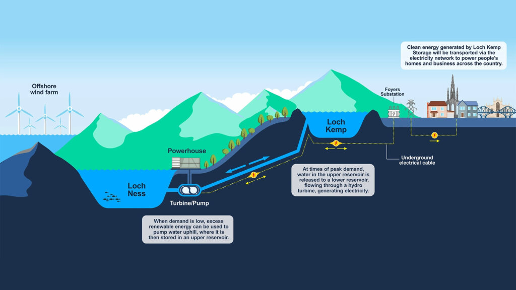
The Loch Kemp pumped storage hydro storage approach

Key Milestones

Documents

Additional Information - April 2025

Additional Information - September 2024

Environmental Impact Assessment

Derogation Report

Non-technical Summary

Planning Statement

Shadow Habitat Regulations Assessment

Volume 1 - Main Report

Volume 2 – Figures

Volume 2 - Contents and Cover
Volume 2 - Figure 1.1 - Site Location
Volume 2 - Figure 1.2 - Site Context
Volume 2 - Figure 2.1 - Switching Station Site Selection
Volume 2 - Figure 3.1 - Proposed Development
Volume 2 - Figure 3.2 - Visualisation Locations
Volume 2 - Figure 3.3 - Typical Dam Plan & Sections
Volume 2 - Figure 3.4 - Indicative Layout of Lower Reservoir Works - During Construction
Volume 2 - Figure 3.5 - Indicative Layout of Lower Reservoir Works - During Operation
Volume 2 - Figure 3.6 - Typical Access Track Construction Details within Ness Woods SAC
Volume 2 - Figure 3.7 - Typical Access Track Construction Details outside Ness Woods SAC
Volume 2 - Figure 3.8 - Proposed Development with Working Corridor and Indicative Borrow Pit Excavations
Volume 2 - Figure 7.1 - Loch Ness Hydrological Catchment Area
Volume 2 - Figure 7.2 - Major Water Features and Hydro Development
Volume 2 - Figure 7.3 - Historical Loch Ness Levels with Pumped Hydro Curtailment Levels
Volume 2 - Figure 7.4 - Ness Weir Overview
Volume 2 - Figure 8.1 - Study Area with ZTV
Volume 2 - Figure 8.2 - Designated and Protected Landscapes with ZTV
Volume 2 - Figure 8.3 - Landscape Character Types with ZTV
Volume 2 - Figure 8.4 - Potential Visual Receptors with ZTV
Volume 2 - Figure 8.5 - Visual Receptors Included within Assessment with ZTV
Volume 2 - Figure 8.6 - Visualisation Locations with ZTV
Volume 2 - Figure 9.1 - Land Use and Recreation
Volume 2 - Figure 10.1 - Locations of Designated Sites within 10 km
Volume 2 - Figure 10.2 - Ancient Woodland Inventory
Volume 2 - Figure 10.3 - Phase 1 Map with Proposed Infrastructure
Volume 2 - Figure 10.4 - NVC Habitat Map with Proposed Infrastructure
Volume 2 - Figure 10.5 - Ness Woods SAC with Permanent Infrastructure
Volume 2 - Figure 10.6 - Ness Woods SAC Tree Sp. with Proposed Infrastructure
Volume 2 - Figure 10.7 - Potential GWDTE
Volume 2 - Figure 10.8 - Lichens with Proposed Infrastructure
Volume 2 - Figure 10.9 - Bryophytes with Proposed Infrastructure
Volume 2 - Figure 10.11 Overview of Ness Woods SAC Compensation Measures
Volume 2 - Figure 11.1 - Ornithological Survey Areas
Volume 2 - Figure 11.2 Internationally Designated Sites of Conservation Importance
Volume 2 - Figure 11.3 - Nationally Designated for Nature Conservation Importance
Volume 2 - Figure 11.4 - Breeding Bird Survey - Birds of Conservation Concern
Volume 2 - Figure 14.1 - Local Hydrology
Volume 2 - Figure 14.2 - Soils
Volume 2 - Figure 14.3 - Peatland Classification
Volume 2 - Figure 14.4 - Superficial Geology
Volume 2 - Figure 14.5a - Bedrock Geology
Volume 2 - Figure 14.5b - Bedrock Geology Legend
Volume 2 - Figure 14.6 - Regional Hydrogeology
Volume 2 - Figure 14.7 - Groundwater Vulnerability
Volume 2 - Figure 14.8 - Potential GWDTE
Volume 2 - Figure 15.1 Cultural Heritage - Inner Study Area
Volume 2 - Figure 15.2 - Cultural Heritage - Outer Study Area with ZTV
Volume 2 - Figure 16.1 - Study Area
Volume 2 - Figure 16.2 - Traffic Count Locations
Volume 2 - Figure 16.3 - Accident Locations
Volume 2 - Figure 16.4 - Construction Vehicle Delivery Routes
Volume 2 - Figure 17.1 - Noise Sensitive Receptors (NSRs) and Noise Monitoring Locations (NMLs)
Volume 2 - Figure 18.1 - Human Receptor Locations
Volume 2 - Figure 18.2 - Ecological Receptors
Volume 2 - Figure 18.3 - NMRR Assessment (Ecological Receptors)

Volume 3a – Nature Scot Visualisations

Volume 3b – The Highland Council Visualisations

Volume 4 - Technical Appendices

Volume 4 - Contents and Cover
Volume 4 - Appendix 3.1 - Design and Sustainability Statement
Volume 4 - Appendix 3.2 - Schedule of Mitigation
Volume 4 - Appendix 3.3 - Outline CEMP
Volume 4 - Appendix 3.4 - Outline Spoil Management Plan
Volume 4 - Appendix 3.5 - Draft Borrow Pit Screening Report Assessment
Volume 4 - Appendix 3.6 - Carbon Balance
Volume 4 - Appendix 4.1 - Team Table
Volume 4 - Appendix 5.1 - Scoping Opinion
Volume 4 - Appendix 5.2 - Scoping Matrix
Volume 4 - Appendix 5.3 - Gate Check Report
Volume 4 - Appendix 5.4 - Gate Check Matrix
Volume 4 - Appendix 5.5 - Further Consultation with Consultees
Volume 4 - Appendix 5.6 - PAC Report
Volume 4 - Appendix 6.1 - NPF4 Policies Relevant to the Proposed Development
Volume 4 - Appendix 6.2 - HwLDP Policies Relevant to the Proposed Development
Volume 4 - Appendix 7.1 - Loch Ness Hydrological Modelling Technical Note
Volume 4 - Appendix 8.1 - Technical Methodologies for Visual Representation
Volume 4 - Appendix 8.2 - Visual Assessment Tables
Volume 4 - Appendix 8.3 - Assessment of Landscape Character Types
Volume 4 - Appendix 8.4 - Assessment of Special Landscape Area
Volume 4 - Appendix 8.5 - Appraisal of THCs Criteria for the Consideration of Onshore Wind Proposals
Volume 4 - Appendix 9.1 - Draft Outdoor Access Management Plan
Volume 4 - Appendix 10.1 - Terrestrial Ecology Report
Volume 4 - Appendix 10.2 - Bryophyte Survey Report
Volume 4 - Appendix 10.3 - Terrestrial Lichen Survey Report
Volume 4 - Appendix 10.4 - Freshwater Lichen Survey Report
Volume 4 - Appendix 10.5 - Ness Woods SAC Tree Tagging
Volume 4 - Appendix 10.6 - Eco-hydrological Assessment
Volume 4 - Appendix 10.7 - Outline HMP non SAC
Volume 4 - Appendix 11.1 - Ornithology Field Survey Methodology
Volume 4 - Appendix 11.2 - Ornithological Baseline Survey Results
Volume 4 - Appendix 11.3 - Local Ornithological Receptors
Volume 4 - Appendix 12.1 - Loch Kemp Baseline Aquatic Surveys
Volume 4 - Appendix 14.1 - Peat Management Plan
Volume 4 - Appendix 14.2 - PLHRA
Volume 4 - Appendix 14.3 - Schedule of Watercourse Crossings
Volume 4 - Appendix 16.1 - Transport Asssessment
Volume 4 - Appendix 17.1 - Baseline Noise Data
Volume 4 - Appendix 17.2 - Road Traffic Noise Calculation
Volume 4 - Appendix 17.3 - Outline CNVMP
Volume 4 - Appendix 17.4 - Source Noise Data during Operation
Volume 4 - Appendix 17.5 - Noise modelling of Associated Works (Switching Station)
Volume 4 - Appendix 18.1 - Dust Monitoring Scheme
Volume 4 - Appendix 19.1 - Dell Estate Woodland Management Plan 2022-2041
Volume 4 - Appendix 19.2 - Woodland Management Plan
Volume 4 - Appendix 19.3 - Forest to Bog Restoration Proposals
Volume 4 - Appendix 20.1 - Socio-economic Baseline
Volume 4 - Appendix 20.2 - Tourism Baseline

Pre Application Public Exhibition Documents

Scoping Documents